Steve HendersonPenn State Geographic Information Systems Certificate Program |
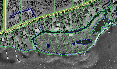
My JobI am a Civil Engineer in the Public Works Department of the City of Gulf Shores, Alabama. In addition to the work I do for the Public Works Department (small project design, maintenance contracts, and drainage review for private developments and subdivisions), I have become "computer guy" for the City, purchasing computers, managing our networks, internet connections, email, the City's original web page (which has since been revamped and expanded by our Administrative Assistant) and now of course, GIS. The link below will take you to the City's web site, www.ci.gulf-shores.al.us.My GIS ExperienceMy first experience with GIS was an early experimental Intergraph/ Microstation based GIS created for the Army at Fort Benning, GA in the late 80's. While I was a student co-op, I created maps of utility locations and site topography for projects under design. Later as an engineer, I used both the maps and the associated database for the design of repairs for a sewer line project. After I came to the City of Gulf Shores, we received a ESRI based GIS created by the Baldwin County Tax Assessor's office. I have begun to use the maps for projects related to Airport Height and Noise overlay districts and hope to use what I will learn from this program to help other City departments develop GIS applications. The picture below was generated from Gulf Shores' GIS, showing parcels, street edges, and water features overlaid onto an aerial photo of the north side of Little Lagoon.
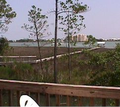
MeI have lived on the Gulf Coast most of my life. I enjoy windsurfing, kayaking, tennis, and college football (Auburn Tigers, and now Nittany Lions). I also enjoy amateur astronomy and a few years ago created a web site with some of my astrophotographs. Just this summer I was finally able to buy a house on the water here in Gulf Shores. The picture below is the view over Little Lagoon from my back porch, where I like to sit when I read my course assignments.
I can be reached by email at shenderson@ci.gulf-shores.al.us. |
Geography 5121 - The Nature of Geographic InformationThis course provides a comprehensive overview of geographic information technologies, including the global positioning system, land surveys, aerial surveys and photogrammetry, topographic mapping, social surveys such as the U.S. Census, and satellite remote sensing. Students who successfully complete the course are able to specify the characteristics of geographic data needed to perform common GIS tasks, determine whether the required data are available, and recognize the technology required to produce data needed for particular tasks. Students also learn skills required to participate effectively in an online class, including creating and publishing online portfolios of class projects on the World Wide Web.Project 1: Coordinates and ProjectionsProject 2: Mapping the CensusProject 3: Acquiring Geographic Data |
Geography 5222 - Elements of GIS, Part IThis course concerns the ways in which geographic information systems can be used to analyze and communicate geographic information. Students who successfully complete the course are able to use GIS software to analyze both raster and vector data using a variety of techniques, including spatial and attribute queries, map overlay, and buffering. Students also gain experience in designing and producing effective maps. Lesson 1: Introduction to GISLesson 2: Manipulating and Summarizing Attribute DataLesson 3: Analyzing Spatial Data in a GISLesson 4: Address GeocodingLesson 5-6: LayoutsLesson 7: Introduction to Raster GIS AnalysisFinal
Project: Identifying Priority Conservation Areas
|
Geography 5223 - Elements of GIS, Part IIThis course is concerned with how GIS software can be used to integrate geographic data compiled from varied sources. Students who successfully complete the course are able to specify and perform the tasks involved in creating a digital geographic database, including geo-registering scanned base maps, digitizing vector features, entering attribute data, and compiling metadata.GeoRegistering Raster ImagesDatabase Design SpecificationsVoter
Registration Analysis
|
Geography 5224P - Programming and CustomizationThis course utilizes ArcView's Avenue programming language to solve real-world problems that require functionality beyond that of "out-of-the-box" ArcView. No previous programming experience is assumed. Students who successfully complete the course are able to automate repetitive tasks, customize the ArcView interface, and bundle their customizations into a sharable extension file.Basics of ArcView CustomizationFinal
Project: 911 Data Entry Extension Instructions
|